

Announcing SpaceNet 7: The Multi-Temporal Urban Development Challenge
Preface: SpaceNet LLC is a nonprofit organization dedicated to accelerating open source, artificial intelligence applied research for geospatial applications, specifically foundational mapping (i.e., building footprint & road network detection). SpaceNet is run in collaboration by co-founder and managing partner CosmiQ Works, co-founder and co-chair Maxar Technologies, and our partners Amazon Web Services (AWS), Capella Space, Topcoder, IEEE GRSS, the National Geospatial-Intelligence Agency and Planet.
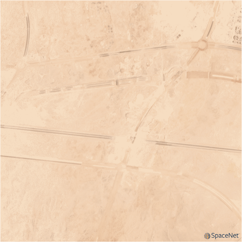
Satellite imagery analytics have numerous human development and disaster response applications, particularly when time series methods are involved. The SpaceNet 7 Multi-Temporal Urban Development Challenge aims to improve these methods, while simultaneously advancing the state of the art in SpaceNet’s core mission of foundational mapping. SpaceNet 7 will be featured as a competition at the 2020 NeurIPS conference in December, and seeks to identify and track buildings in a time series of satellite imagery collected over rapidly urbanizing areas (see Figure 1). Beyond its relevance for disaster response, disease preparedness, and environmental monitoring, this task poses interesting technical challenges for the computer vision community.
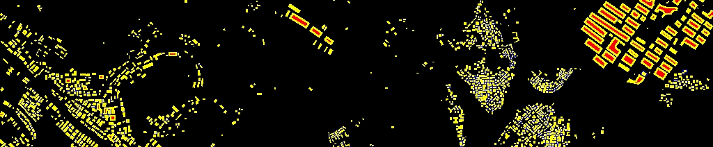
The competition centers around a new open source dataset of Planet satellite imagery mosaics, which will include 24 images (one per month) covering ~100 unique geographies. Each geography features significant urban change over the two-year timespan. The dataset will comprise >40,000 square kilometers of imagery and exhaustive polygon labels of building footprints in the imagery, totaling over 10 million individual annotations (see Figure 2). Challenge participants will be asked to track individual building construction over time, thereby directly assessing urbanization.
SpaceNet 7 poses a unique challenge from a computer vision standpoint because of the small pixel area of each object, the high object density within images, and the dramatic image-to-image difference compared to frame-to-frame variation in video object tracking. We believe this challenge will aid efforts to develop useful tools for overhead change detection.
Competitors will be asked to both localize and track buildings over time (scoring will be a variation of the MOTA metric). What this means is that each building will be assigned a unique identifier (i.e. an address), which must be consistent over time. The ability to uniquely identify buildings in dynamic locales and observation environments (e.g. clouds, haze, seasonality) directly from overhead imagery will be of great utility in one of SpaceNet’s key goals: advancing foundational mapping.
Timely, high-fidelity foundational maps are critical to a great many domains. For example, high-resolution maps help identify communities at risk for natural and human-derived disasters. A specific example in this thread: identifying new building construction in satellite imagery is an important factor in establishing population estimates in many areas (e.g. [1]). Yet population estimates are often inaccurate, out-of-date, or non-existent in many parts of the world. In 2015, the World Bank estimated that 110 countries globally lack effective systems for Civil Registration and Vital Statistics (CRVS), i.e. birth, death, marriage, and divorce registration [2]. CRVS are also fundamental to assessing progress in 67 of the 232 UN Sustainable Development Goals indicators [3]. Inaccurate population estimates can result in poor distribution of government spending and aid distribution, overcrowded hospitals, and inaccurate risk assessments for natural disasters [4]. Thus, the dynamic, high resolution building footprint and address detections anticipated in SpaceNet 7 have the potential to greatly increase the precision of population estimates in poorly mapped areas.
In future posts we will dive deeper into the SpaceNet 7 imagery and labels, and provide further details about what makes this dataset unique. In addition, as the August 31, 2020 launch date approaches, stay tuned for more information about the challenge structure, baseline model, and resources available to explore this rich dataset.
* Thanks to Nick Weir and Jesus Martinez Manso for contributions to this post.
======================================
[1] Engstrom, Ryan; Newhouse, David Locke; Soundararajan, Vidhya. 2019. Estimating Small Area Population Density Using Survey Data and Satellite Imagery : An Application to Sri Lanka (English). Poverty and Equity Global Practice Working Paper; no. 194. Washington, D.C. : World Bank Group.
[2] Mills, S.: Civil registration and vital statistics: key to better data on maternal mortality (Nov 2015)
[3] Mills, S., Abouzahr, C., Kim, J., Rassekh, B.M., Sarpong, D.: Civil registration and vital statistics (crvs) for monitoring the sustainable development goals (sdgs). (2017)
[4] Guha-Sapir, D., Hoyois, P. In: Estimating populations affected by disasters: A review of methodological issues and research gaps. United Nations Sustainable Development Group (March 2015)